LifeScienceHistory.com - Check us out on Instagram
Take Your Next Career Step with Lundback
Geography & Climate
Industry
Snapshot | Economy/Cost of
Living
Education
| Recreation
& Entertainment | Transportation
History | Suggested
Reading List
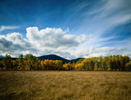 Montana is an immense, high, northern state, dominated by both the Rocky Mountains and the Great Plains. Warm summers, contrasted with cold and snowy winters, characterize Montana’s climate.
Montana is the fourth largest state in the U.S., covering 147,046 square miles (380,849 sq. km). Approximately 1%, or 1,490 square miles (3,859 sq. km), of this area is covered by water. The average elevation of Montana is 3,400 feet (1,036 m). Montana is bordered by Canada to the north, the Dakotas to the east, Idaho to the west and Wyoming to the south.
The Rocky Mountain Region of the state comprises the western portion. This area contains over 50 distinct mountain ranges and countless mountain peaks. The state’s highest elevation point is found here: Granite Peak, at 12,799 feet (3,901 m). Dramatic elevations dictate year-round snow in some of these areas. The Great Plains are found in the eastern portion of Montana. The Great Plains are high, rolling plains, interspersed with fertile river valleys and mountains.
The Continental Divides dissects Montana’s climate. West of the Divide, average January temperatures range from 15-30 degrees F (-9--1 C), while average July temperatures range from 50-83 degrees F (10-28 C). East of the Divide, the weather is typically more extreme, colder in winter and warmer in summer. Average January temperatures in this area range from 1-23 degrees F (-17--5 C), with average July temperatures ranging from 59-88 degrees F (15-31). Annual precipitation ranges from 18 inches (46 cm) west of the Continental Divide to as little as 13 inches (33 cm) to the east. Great differences in temperature from these means occur due to Montana’s high and varying elevation.
Related Resources:
Back to Destination Montana